
Geospatial data is a niche area that is increasingly becoming utilised in the data analytics world. Data relating to geography is becoming more common to identify hidden patterns and spaces which cannot be identified using traditional data analytics approaches.
In its simplest terms, Geospatial data are data points that describe geographical objects or features on the earth’s surface. Data can be obtained from diverse sources such as satellite imagery, social media (e.g., Twitter), meteorology and more. Combining geospatial data with traditional business data can be a powerful analytical tool.
There are two types of geospatial data: vector and raster. Vector data are geographical features such as cities, roads that are represented by geometric locations (x,y values), which define the shape of the geographical object that is being mapped, defined by points, lines and polygons. For example, roads in a city can be represented by lines.
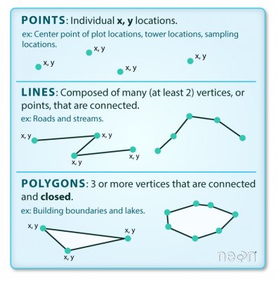
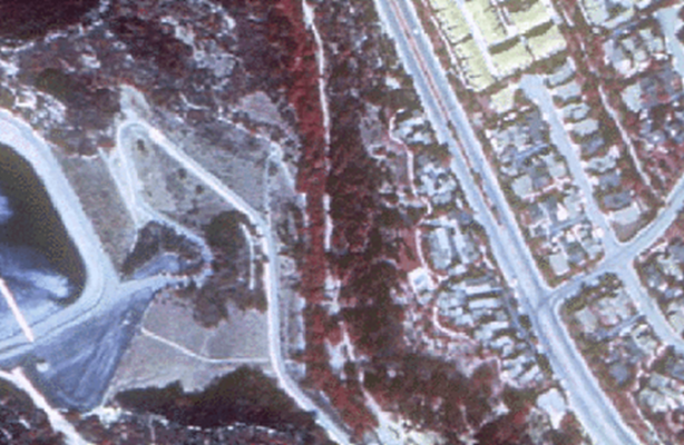
Raster data are made up of pixels, similar to a digital photograph. A single pixel would represent an area on the Earth’s surface. Examples include high resolution satellite imagery.
Why is Geospatial data important?
Large volumes of Geospatial data present many challenges to organisations. Many companies find it difficult to take advantage of utilising and making sense of the data. Approximately 100 TB of data relating to weather data is generated everyday for example, which presents substantial storage and data access dilemmas for many companies. Most companies may not have the IT capability, instrastructure and talent to take full advantage in translating data into useful business decisions.
Additionally, Geospatial data analysis requires technology which may be difficult for many organisations to utilise due to the complexity in translating large, unstructured data that can encompasses different formats, into useful outputs, and the cost, time and experience involved in using the technology.
Adatis leverages its experience in Microsoft technologies to address and solve the the challenges described above. Adatis’s experience in Azure services such as Databricks, Azure maps Power BI, Database for PostgreSQL offer solutions to make large volumes of geospatial data ready for analytics and presenting.
Realising the benefits of geospatial analytics can help organisations gain a deeper understanding of their data, for example, companies can use geospatial data to help companies decide where to set up shop depending on how much potential target customers are likely to visit your store. Geospatial analysis can be used to show how accessible is transportation to your site. Other use cases include network planning, competitive intelligence, consumer insights and more.
Geospatial data will become increasingly sophisticated in the future, with advanced technologies such as AI and machine learning improving and becoming more integrated with geospatial analytics. Newer ways of collecting data such as using drones for aerial mapping and autonomous vehicles will increase the viability and strength of geospatial data analytics for consumer or industrial needs. Adatis is in a strong position to help businesses take advantage of these developments thanks to our deep and rich experience in Azure cloud services and provide customers with gaining a deeper insight into there data that otherwise could have been missed.
The next series of blogs will explain technical architectures used in geospatial analysis and the technical routes in which geospatial data can be analysed across storage, processing, and display.
Introduction to Data Wrangler in Microsoft Fabric
What is Data Wrangler? A key selling point of Microsoft Fabric is the Data Science
Jul
Autogen Power BI Model in Tabular Editor
In the realm of business intelligence, Power BI has emerged as a powerful tool for
Jul
Microsoft Healthcare Accelerator for Fabric
Microsoft released the Healthcare Data Solutions in Microsoft Fabric in Q1 2024. It was introduced
Jul
Unlock the Power of Colour: Make Your Power BI Reports Pop
Colour is a powerful visual tool that can enhance the appeal and readability of your
Jul
Python vs. PySpark: Navigating Data Analytics in Databricks – Part 2
Part 2: Exploring Advanced Functionalities in Databricks Welcome back to our Databricks journey! In this
May
GPT-4 with Vision vs Custom Vision in Anomaly Detection
Businesses today are generating data at an unprecedented rate. Automated processing of data is essential
May
Exploring DALL·E Capabilities
What is DALL·E? DALL·E is text-to-image generation system developed by OpenAI using deep learning methodologies.
May
Using Copilot Studio to Develop a HR Policy Bot
The next addition to Microsoft’s generative AI and large language model tools is Microsoft Copilot
Apr